GPS AND SONAR
GARMIN Navionics Cartography
GPSMAP 723/923/1223 (xsv)
All-in-one transducers
Garmin GMR 18 HD+ radar antenna.
Radar antenna GMR Fantom 18x
RAYMARINE Lighthouse Chart.
Chartplotter echoMAP Ultra GARMIN.
Portable GPS GARMIN GPS73
Chartplotter echoMAP UHD2 GARMIN.
GPSMAP 86 GARMIN
Fuel flow sensor (gasoline) GFS 10
Portable GPS GARMIN GPSMAP 79s
Navionics Aggiornamenti
CHIRP GARMIN transducers in bronze.
GARMIN gWind transducers
inReach® Mini 2 Marine Bundle
RAYMARINE Lighthouse Chart
GPS antennas GARMIN
NAVIONICS Cartography
GPSMAP 86 GARMIN
GARMIN GPSMAP 923xsv with fishfinder module.
SideVü, ClearVü and traditional CHIRP sonar with preloaded worldwide basemap - no radar
The new Garmin GPSMAP series has higher resolution and faster processor performance. The 9" touchscreen offers an optimized user interface and can easily be integrated into the Garmin marine system. CHIRP sonar, ClearVü, and SideVü provide a detailed view of fish and underwater structure. The Garmin GPSMAP series also offers integrated autopilot control, compatibility with Garmin radar, and built-in wireless connectivity. The Quickdraw Contours feature allows for real-time creation of custom maps.
Multifunctional GPS Watch Quatix by GARMIN
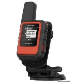
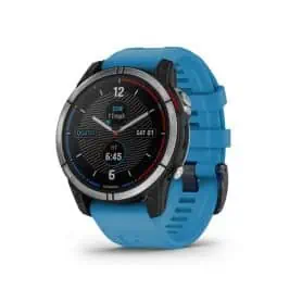
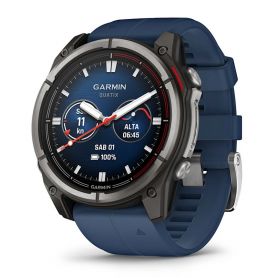
Discover your passion for boating with the new Garmin Quatix 7 GPS smartwatch. With its dedicated features, you'll have everything you need to navigate on open waters. Quatix 7 connects to compatible Garmin chartplotters and other devices to display boat data directly on your wrist. With a rugged and refined design, you can wear it in any condition, even underwater, thanks to its water resistance up to 100 meters deep. The battery life lasts for approximately 18 days in smartwatch mode, and the display is easy to read even under direct sunlight. Additionally, with BlueChart g3 mapping, you can access Garmin content and Navionics data for safe navigation.
Cartography for Lowrance, B&G, Simrad Tyrrhenian Sea Islands
Discover a new navigation and fishing experience with DISCOVER M-EM-Y201 cartography, compatible with Lowrance, B&G and Simrad instruments. Designed to offer the highest level of detail, this map covers the Tyrrhenian Coast and Islands, providing a clear and accurate view of the seabed.
The vector charts include depths, contours, sounding points, nautical aids (NavAids), light sectors, wrecks, obstacles and much more. Each element is designed to offer safer navigation and more effective fishing. You can set custom safety depths and easily locate underwater pinnacles, canyons and ledges, which are real hotspots for coastal game.
Support is guaranteed on SD or MSD cards up to 32 GB.

