Radio stereo with USB/Bluetooth and remote control.
€157.14
€224.48
-30%

Official nautical chart of the Italian Hydrographic Institute of the Navy, produced on a scale of 1:100,000, representing the stretch of sea from Castelsardo to Olbia/Bocche di Bonifacio. Printed on a large sheet measuring 83 x 116 cm, the chart offers a detailed representation of the coastline, seabed and main nautical features of the area, making it an indispensable tool for navigating this stretch of the Mediterranean Sea. Ideal for yachtsmen, sea professionals and enthusiasts, it combines technical precision and graphic quality, according to the high standards of the Hydrographic Institute of the Navy.
Nautical chart of the Hydrographic Institute of the Navy, in SCALE 1:100,000, printed on sheet size 116 x 83 cm. NOT TO BE USED FOR NAVIGATION from Castel sardo to Olbia/Bocche Bonifacio.
Official nautical chart of the Italian Navy Hydrographic Institute, scale 1:100,000, from Olbia to Capo di Monte Santu Printed on a large sheet measuring 83 x 116 cm, the chart offers a detailed representation of the coastline, seabed and main nautical features of the area, making it an indispensable tool for navigating this stretch of the Mediterranean Sea. Ideal for yachtsmen, sea professionals and enthusiasts, it combines technical precision and graphic quality, according to the high standards of the Hydrographic Institute of the Navy.
Official nautical chart from the Italian Hydrographic Institute of the Navy, at a scale of 1:100,000, designed to ensure accuracy and reliability in coastal navigation. Printed on a large-format sheet (116 × 83 cm), it provides a clear and detailed representation of the stretch of sea from Capo Carbonara to Capo Spartivento.
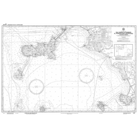
Official nautical chart of the Istituto Idrografico della Marina, produced on a scale of 1:100,000, representing Olbia and Golfo Aranci. Printed on a large sheet measuring 83 x 116 cm, the chart offers a detailed representation of the coastline, seabed and main nautical features of the area, making it an indispensable tool for navigation in this part of the Mediterranean Sea. Ideal for yachtsmen, sea professionals and enthusiasts, it combines technical precision and graphic quality, according to the high standards of the Hydrographic Institute of the Navy.
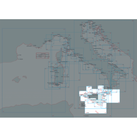
Nautical chart of the Hydrographic Institute of the Navy (LIGURY SEA - TYRRANEAN SEA - STRAIT OF SICILY)
Navigate with precision through the Ligurian Sea, Tyrrhenian Sea and Strait of Sicily thanks to this official nautical chart of the Hydrographic Institute of the Navy, produced at a scale of 1:1,000,000.
Area represented: sector of the Ligurian Sea and Central-Northern Tyrrhenian Sea, perfect for deep-sea navigation and long-range orientation.
Technical details: printed on high quality, durable foil, with dimensions of 83 x 116 cm.
Authenticity: compliance with the highest standards of cartographic accuracy of the Hydrographic Institute of the Navy.
Indispensable for navigation professionals, sea enthusiasts and chart collectors.
Official nautical chart from the Italian Hydrographic Institute of the Navy, at a scale of 1:100,000, designed to ensure accuracy and reliability in coastal navigation. Printed on a large-format sheet (116 × 83 cm), it provides a clear and detailed representation Corsica island.
Official nautical chart of the Italian Hydrographic Institute of the Navy, produced on a scale of 1:100,000, representing the stretch of sea from Cape Bellavista to the Strait of Bonifacio. Printed on a large sheet measuring 83 x 116 cm, the chart offers a detailed representation of the coastline, seabed and main nautical features of the area, making it an indispensable tool for navigating this stretch of the Mediterranean Sea. Ideal for yachtsmen, sea professionals and enthusiasts, it combines technical precision and graphic quality, according to the high standards of the Hydrographic Institute of the Navy.
Official nautical chart from the Italian Hydrographic Institute of the Navy, at a scale of 1:100,000, designed to ensure accuracy and reliability in coastal navigation. Printed on a large-format sheet (116 × 83 cm), it provides a clear and detailed representation of the stretch of sea from the Piombino Channel to Fiumicino, including the eastern coast of Corsica.
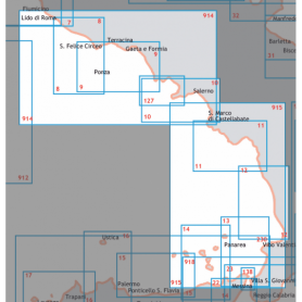
Explore the Central-Southern Tyrrhenian Sea with this official nautical chart of the Hydrographic Institute of the Navy, produced at a scale of 1:250,000.
Area covered: from Fiumicino to Punta Licosa, perfect for route planning and coastal navigation.
Technical details: printed on high quality sheet, with dimensions of 116 x 83 cm.
Officiality: guarantee of accuracy and updates according to the standards of the Hydrographic Institute of the Navy.
An essential tool for mariners, fishermen and sea enthusiasts, ideal for safe planning or for collectors of nautical maps.
Available now to enrich your navigation experience!
Official nautical chart published by the Italian Hydrographic Institute of the Navy, at a scale of 1:100,000. Ideal for coastal navigation planning and accurate route reference.
This chart covers the area from Capo Orlando to Capo Zafferano, including the island of Filicudi, and provides essential navigational information for safe boating.
Features:
Official chart produced by the Italian Navy Hydrographic Institute, scale 1:250,000, printed on large sheets (116 x 83 cm). It covers the stretch of sea from Capo Rossello to Augusta, including the Maltese Islands.
Ideal for coastal and offshore navigation, it provides detailed information on bathymetry, seabeds, maritime signals, ports, and main coastal landmarks, ensuring accuracy and reliability in accordance with official cartographic standards.
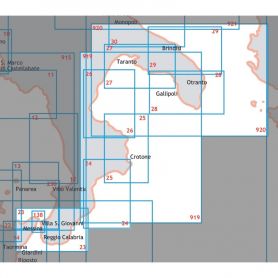
Official nautical chart from the Italian Hydrographic Institute of the Navy, at a scale of 1:100,000, designed to ensure accuracy and reliability in coastal navigation. Printed on a large-format sheet (116 × 83 cm), it provides a clear and detailed representation of the stretch of sea from Augusta to Punta Stilo.
Official nautical chart from the Italian Hydrographic Institute of the Navy, at a scale of 1:100,000, designed to ensure accuracy and reliability in coastal navigation. Printed on a large-format sheet (116 × 83 cm), it provides a clear and detailed representation of the stretch of sea from Punta Stilo to Cape Santa Maria di Leuca.
Pick a color, then click OK