Radio stereo with USB/Bluetooth and remote control.
€157.14
€224.48
-30%

Official nautical chart from the Italian Hydrographic Institute of the Navy, at a scale of 1:100,000, designed to ensure accuracy and reliability in coastal navigation. Printed on a large-format sheet (116 × 83 cm), it provides a clear and detailed representation of the stretch of sea from Augusta to Punta Stilo.
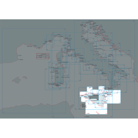
Official nautical chart published by the Istituto Idrografico della Marina, produced at a scale of 1:250,000, ideal for coastal and offshore navigation planning in the central and southern Adriatic Sea.
The chart covers the maritime area from Torre Canne to Vieste, including the Bocche di Cattaro (also known as the Bay of Kotor), a strategic location in the southern Adriatic.
Scale: 1:250,000
Sheet dimensions: 116 × 83 cm
Type: Official nautical chart
Publisher: Istituto Idrografico della Marina
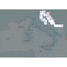
This official nautical chart of the Hydrographic Institute of the Navy accurately depicts the area of the north-central Adriatic, extending from Porto San Giorgio to Porto Corsini. Made at a scale of 1:250,000 and printed on an 83 x 116 cm sheet, it provides a detailed view of the coastline and maritime features of the area.
The C-MAP DISCOVER cartridge for the Italy Mediterranean West Coast area is a modern and complete cartographic solution, ideal for yachtsmen, fishermen and sailors who wish to safely and accurately explore the entire western strip of Italy, from the French border to Calabria, including the major islands such as Sardinia, Corsica and Elba.
High-quality, up-to-date vector cartography compatible with leading Lowrance, Simrad and B&G chartplotters
Detailed isobaths for clear representation of the seabed, ideal for both coastal navigation and fishing
Nautical points of interest such as harbours, anchorages, shore services and useful information for stopping and refuelling
Auto Routing Easy Routing™, which automatically suggests safe routes based on depth and vessel size.
The 42D Educational Chart – Official nautical cartography of the Italian Navy Hydrographic Institute, on a scale of 1:100,000, is an educational tool designed to introduce students to the study and use of official Italian nautical cartography. The 42D is mainly used in training contexts—for example, in courses for obtaining a nautical license or in nautical technical institutes—for chart work exercises, route tracing, surveying, and ship position calculation. While maintaining the layout and authority of the official production of the Hydrographic Institute of the Navy, its main purpose is to teach traditional paper-based navigation techniques.
Official nautical chart of the Italian Hydrographic Institute of the Navy, produced on a scale of 1:100,000, representing the stretch of sea from Castelsardo to Olbia/Bocche di Bonifacio. Printed on a large sheet measuring 83 x 116 cm, the chart offers a detailed representation of the coastline, seabed and main nautical features of the area, making it an indispensable tool for navigating this stretch of the Mediterranean Sea. Ideal for yachtsmen, sea professionals and enthusiasts, it combines technical precision and graphic quality, according to the high standards of the Hydrographic Institute of the Navy.
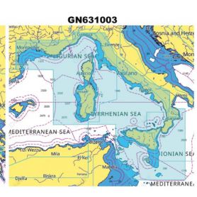
Nautical chart of the Hydrographic Institute of the Navy (LIGURY SEA - TYRRANEAN SEA - STRAIT OF SICILY)
Navigate with precision through the Ligurian Sea, Tyrrhenian Sea and Strait of Sicily thanks to this official nautical chart of the Hydrographic Institute of the Navy, produced at a scale of 1:1,000,000.
Area represented: sector of the Ligurian Sea and Central-Northern Tyrrhenian Sea, perfect for deep-sea navigation and long-range orientation.
Technical details: printed on high quality, durable foil, with dimensions of 83 x 116 cm.
Authenticity: compliance with the highest standards of cartographic accuracy of the Hydrographic Institute of the Navy.
Indispensable for navigation professionals, sea enthusiasts and chart collectors.
Official nautical chart from the Italian Hydrographic Institute of the Navy, at a scale of 1:100,000, designed to ensure accuracy and reliability in coastal navigation. Printed on a large-format sheet (116 × 83 cm), it provides a clear and detailed representation Corsica island.
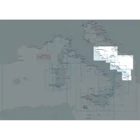
Explore the Central-Southern Tyrrhenian Sea with this official nautical chart of the Hydrographic Institute of the Navy, produced at a scale of 1:250,000.
Area covered: from Fiumicino to Punta Licosa, perfect for route planning and coastal navigation.
Technical details: printed on high quality sheet, with dimensions of 116 x 83 cm.
Officiality: guarantee of accuracy and updates according to the standards of the Hydrographic Institute of the Navy.
An essential tool for mariners, fishermen and sea enthusiasts, ideal for safe planning or for collectors of nautical maps.
Available now to enrich your navigation experience!
Official nautical chart from the Italian Hydrographic Institute of the Navy, at a scale of 1:100,000, designed to ensure accuracy and reliability in coastal navigation. Printed on a large-format sheet (116 × 83 cm), it provides a clear and detailed representation of the stretch of sea from Punta Stilo to Cape Santa Maria di Leuca.
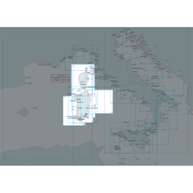
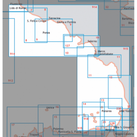
Portolano del mediterraneo dell' Istituto Ideografico della Marina. They provide regulatory, geographical, oceanographic and meteorological information. They are the indispensable complement to the nautical chart. From Cape Circeo to Sapri
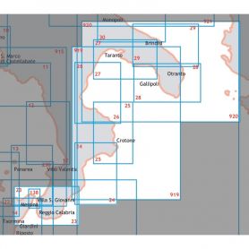
Mediterranean Pilot of the Marine Ideographic Institute. They provide regulatory, geographical, oceanographic, and meteorological information. They are an indispensable complement to nautical charts. Southern and Northern Sicily
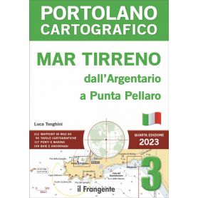
This pilot book describes the Tyrrhenian coast from the Argentario promontory to Punta Pellaro on the Calabrian coast opposite the Strait of Messina. This stretch of coastline is flanked by islands, the main ones being Giglio, the Pontine Islands, Ischia and Capri.
The volume is divided into five main areas and comprises 96 charts providing detailed illustrations of harbour plans, landing places and anchorages.
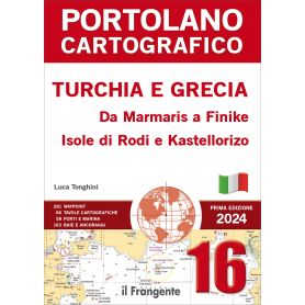
This pilot describes one of the most picturesque stretches of Turkey’s southern coast, from Marmaris to Finike, and the Greek islands of Rhodes and Kastellorizo.
The volume is divided into five main areas and comprises 86 charts providing detailed illustrations of harbour plans, landing places and anchorages.
The introduction includes information on entry formalities, distances and main routes, nautical charts of the navigation area and meteorological information.
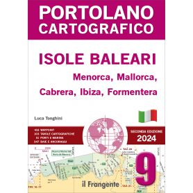
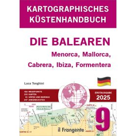
This pilot, comprising 103 charts, provides a detailed description of the Balearic archipelago, consisting of the islands of Menorca, Mallorca, Cabrera, Ibiza and Formentera. The introduction includes distances and main routes, traditional and digital charts, and general meteorological information.
The navigation area is divided into five macro-zones, each of which includes a quick guide to the main ports and marinas, along with their facilities (water and electricity supply, fuel, technical assistance, etc.).
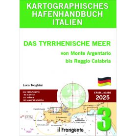
This port guide covers the entire Tyrrhenian coast from Monte Argentario to Reggio Calabria, a stretch of coastline renowned for its fascinating islands and archipelagos. Among these are the Pontine Islands, Capri, and Ischia, which rank among the most enchanting destinations in the Mediterranean.
The highlight of the guide is its 96 detailed charts, which comprehensively describe harbors, landing places, and anchorage points. These are complemented by an overview chart showing distances and main routes, as well as nautical charts of the sailing areas.
The book is entirely in German.
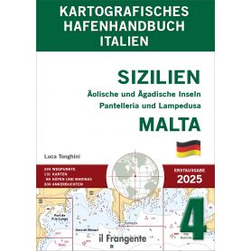
This harbour guide covers the coast of Sicily as well as the surrounding Aeolian and Aegadian Islands, the island of Pantelleria, the Pelagie Islands and the Maltese Islands.
The focus of the guide is on 131 detailed charts, which provide comprehensive descriptions of harbours, moorings and anchorages.
These are supplemented by an overview map showing distances and main routes, as well as nautical charts of the navigation zones. Valuable weather information for each sea area, including local conditions, aids in the careful planning of a voyage.
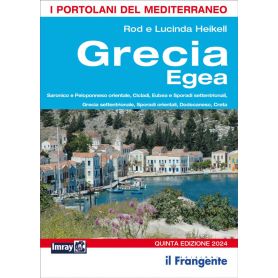
Now in its fifth edition, this pilot guide remains an essential reference for sailors wishing to explore this cruising area, which is extraordinarily rich in islands, anchorages and landing places, set against a natural and historical-cultural backdrop of great beauty and interest. The volume describes the coastline starting from the Saronic Gulf and covers the entire Aegean, including the island of Crete, the Cyclades, the Sporades and the Dodecanese archipelago, before heading down to the small island of Kastellorizo, the southernmost Greek outpost in the far eastern Mediterranean. This pilot, which stands out for the wealth of information characteristic of Imray nautical guides, is considered an indispensable tool for anyone wishing to explore this corner of the Mediterranean.
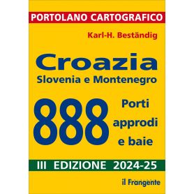
The eastern Adriatic coast is, along with Greece, one of the most popular cruising destinations in the Mediterranean, with over 1,200 islands and 800 kilometres of coastline, offering a vast array of landing places, marinas and anchorages – a choice that can be overwhelming. This pilot, comprising 99 general charts, has everything required to meet the needs of the yachtsman: compact, with clear graphics, comprehensive, up-to-date and reliable.
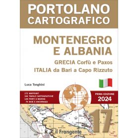
This pilot book, comprising 166 charts, provides a detailed description of the coasts of Montenegro and Albania. For the sake of completeness, it also includes neighbouring navigation areas, covering the Ionian coasts of Italy from Bari to Capo Rizzuto, the islands of Corfu and Paxos, and the Greek mainland coast from the Albanian border to Ligia.
The introduction sets out the distances and main routes for the entire area, the necessary charts and entry formalities.
The navigation area is divided into six macro-zones, for each of which a quick guide to the main ports and marinas, along with their facilities, is provided.
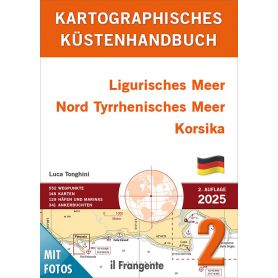
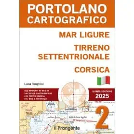
This harbour guide covers the Ligurian Sea, the northern Tyrrhenian Sea and the coasts of Corsica.
The highlight of the guide is the 146 detailed charts, which provide a comprehensive description of harbours, landing places and anchorages. These are supplemented by a general chart showing distances and main routes, as well as nautical charts of the navigation areas.
Valuable meteorological information for each maritime area, including local conditions, helps you to plan your cruise carefully.
This pilot book describes the coasts of Liguria and Tuscany, along with the islands off their coasts, and Corsica, in 148 charts.
The introduction includes general information on the sailing area, distances and main routes, a list of useful nautical charts, and general meteorological information.
The volume is divided into five macro-zones, each of which includes a quick guide to the main ports and marinas and their facilities.
This coastal guide covers the Balearic Islands, comprising five islands: Menorca, Mallorca, Cabrera, Ibiza and Formentera. Its key feature is the 103 detailed charts providing comprehensive information on harbours, landing places and anchorages. These are supplemented by an overview chart showing distances and main routes, as well as nautical charts of the navigation areas.
Valuable meteorological information for each maritime area, including local conditions, helps you plan your cruise carefully. The guide divides the area into five navigation zones, for each of which clear information tables are provided, summarising repair, refuelling and technical assistance services.
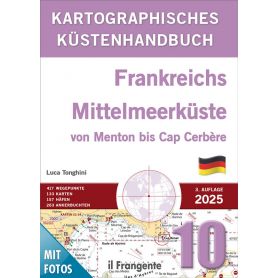
This harbour guide covers the French Mediterranean coast from the Italian-French border to the French-Spanish border. It includes the so-called Riviera, the entire Côte d’Azur, Provence and the Languedoc-Roussillon region.
The focus of this coastal guide is on 133 detailed charts, which provide comprehensive descriptions of harbours, moorings and anchorages. These are supplemented by an overview map showing distances and main routes, as well as nautical charts of the navigation zones.
Valuable weather information for each sea area, including local features, helps with the careful planning of a voyage.
Pick a color, then click OK