Radio stereo with USB/Bluetooth and remote control.
€157.14
€224.48
-30%

Official nautical chart of the Italian Hydrographic Institute of the Navy, produced on a scale of 1:100,000, representing the stretch of sea from Castelsardo to Olbia/Bocche di Bonifacio. Printed on a large sheet measuring 83 x 116 cm, the chart offers a detailed representation of the coastline, seabed and main nautical features of the area, making it an indispensable tool for navigating this stretch of the Mediterranean Sea. Ideal for yachtsmen, sea professionals and enthusiasts, it combines technical precision and graphic quality, according to the high standards of the Hydrographic Institute of the Navy.
Nautical chart of the Hydrographic Institute of the Navy, in SCALE 1:100,000, printed on sheet size 116 x 83 cm. NOT TO BE USED FOR NAVIGATION from Castel sardo to Olbia/Bocche Bonifacio.
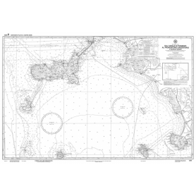
Official nautical chart of the Italian Navy Hydrographic Institute, scale 1:100,000, from Olbia to Capo di Monte Santu Printed on a large sheet measuring 83 x 116 cm, the chart offers a detailed representation of the coastline, seabed and main nautical features of the area, making it an indispensable tool for navigating this stretch of the Mediterranean Sea. Ideal for yachtsmen, sea professionals and enthusiasts, it combines technical precision and graphic quality, according to the high standards of the Hydrographic Institute of the Navy.
Official nautical chart from the Italian Hydrographic Institute of the Navy, at a scale of 1:100,000, designed to ensure accuracy and reliability in coastal navigation. Printed on a large-format sheet (116 × 83 cm), it provides a clear and detailed representation of the stretch of sea from Capo Carbonara to Capo Spartivento.
Official nautical chart of the Istituto Idrografico della Marina, produced on a scale of 1:100,000, representing Olbia and Golfo Aranci. Printed on a large sheet measuring 83 x 116 cm, the chart offers a detailed representation of the coastline, seabed and main nautical features of the area, making it an indispensable tool for navigation in this part of the Mediterranean Sea. Ideal for yachtsmen, sea professionals and enthusiasts, it combines technical precision and graphic quality, according to the high standards of the Hydrographic Institute of the Navy.
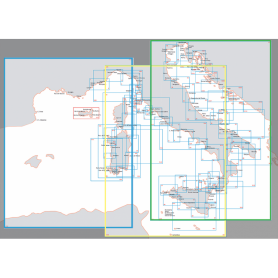
Nautical chart of the Hydrographic Institute of the Navy (LIGURY SEA - TYRRANEAN SEA - STRAIT OF SICILY)
Navigate with precision through the Ligurian Sea, Tyrrhenian Sea and Strait of Sicily thanks to this official nautical chart of the Hydrographic Institute of the Navy, produced at a scale of 1:1,000,000.
Area represented: sector of the Ligurian Sea and Central-Northern Tyrrhenian Sea, perfect for deep-sea navigation and long-range orientation.
Technical details: printed on high quality, durable foil, with dimensions of 83 x 116 cm.
Authenticity: compliance with the highest standards of cartographic accuracy of the Hydrographic Institute of the Navy.
Indispensable for navigation professionals, sea enthusiasts and chart collectors.
Official nautical chart from the Italian Hydrographic Institute of the Navy, at a scale of 1:100,000, designed to ensure accuracy and reliability in coastal navigation. Printed on a large-format sheet (116 × 83 cm), it provides a clear and detailed representation Corsica island.
Official nautical chart of the Italian Hydrographic Institute of the Navy, produced on a scale of 1:100,000, representing the stretch of sea from Cape Bellavista to the Strait of Bonifacio. Printed on a large sheet measuring 83 x 116 cm, the chart offers a detailed representation of the coastline, seabed and main nautical features of the area, making it an indispensable tool for navigating this stretch of the Mediterranean Sea. Ideal for yachtsmen, sea professionals and enthusiasts, it combines technical precision and graphic quality, according to the high standards of the Hydrographic Institute of the Navy.
Official nautical chart from the Italian Hydrographic Institute of the Navy, at a scale of 1:100,000, designed to ensure accuracy and reliability in coastal navigation. Printed on a large-format sheet (116 × 83 cm), it provides a clear and detailed representation of the stretch of sea from the Piombino Channel to Fiumicino, including the eastern coast of Corsica.
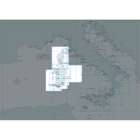
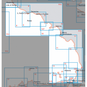
Explore the Central-Southern Tyrrhenian Sea with this official nautical chart of the Hydrographic Institute of the Navy, produced at a scale of 1:250,000.
Area covered: from Fiumicino to Punta Licosa, perfect for route planning and coastal navigation.
Technical details: printed on high quality sheet, with dimensions of 116 x 83 cm.
Officiality: guarantee of accuracy and updates according to the standards of the Hydrographic Institute of the Navy.
An essential tool for mariners, fishermen and sea enthusiasts, ideal for safe planning or for collectors of nautical maps.
Available now to enrich your navigation experience!
Official nautical chart published by the Italian Hydrographic Institute of the Navy, at a scale of 1:100,000. Ideal for coastal navigation planning and accurate route reference.
This chart covers the area from Capo Orlando to Capo Zafferano, including the island of Filicudi, and provides essential navigational information for safe boating.
Features:
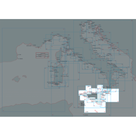
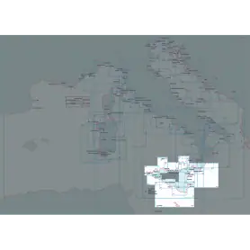
Official chart produced by the Italian Navy Hydrographic Institute, scale 1:250,000, printed on large sheets (116 x 83 cm). It covers the stretch of sea from Capo Rossello to Augusta, including the Maltese Islands.
Ideal for coastal and offshore navigation, it provides detailed information on bathymetry, seabeds, maritime signals, ports, and main coastal landmarks, ensuring accuracy and reliability in accordance with official cartographic standards.
Official nautical chart from the Italian Hydrographic Institute of the Navy, at a scale of 1:100,000, designed to ensure accuracy and reliability in coastal navigation. Printed on a large-format sheet (116 × 83 cm), it provides a clear and detailed representation of the stretch of sea from Augusta to Punta Stilo.
Official nautical chart from the Italian Hydrographic Institute of the Navy, at a scale of 1:100,000, designed to ensure accuracy and reliability in coastal navigation. Printed on a large-format sheet (116 × 83 cm), it provides a clear and detailed representation of the stretch of sea from Punta Stilo to Cape Santa Maria di Leuca.
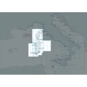
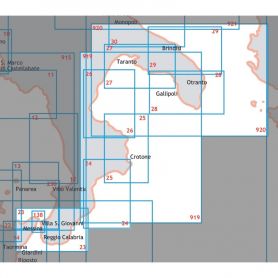
Official nautical chart published by the Istituto Idrografico della Marina, produced at a scale of 1:250,000, ideal for coastal and offshore navigation planning in the central and southern Adriatic Sea.
The chart covers the maritime area from Torre Canne to Vieste, including the Bocche di Cattaro (also known as the Bay of Kotor), a strategic location in the southern Adriatic.
Scale: 1:250,000
Sheet dimensions: 116 × 83 cm
Type: Official nautical chart
Publisher: Istituto Idrografico della Marina
This official nautical chart of the Hydrographic Institute of the Navy accurately depicts the area of the north-central Adriatic, extending from Porto San Giorgio to Porto Corsini. Made at a scale of 1:250,000 and printed on an 83 x 116 cm sheet, it provides a detailed view of the coastline and maritime features of the area.
The Artica Series compass with an apparent Ø of 2 3/4” (70 mm) is a compact and reliable navigation instrument, designed to ensure precision and practicality on board. It features an internal semi-gimballed suspension, which keeps the card stable even in rough seas, and an integrated compensation system to correct possible magnetic deviations.
The standard 12 V lighting ensures perfect readability even during night navigation, while the anti-glare screen and the white graduated card with 5° intervals provide clear and accurate readings. The structure, in black flush-mount design, is both elegant and discreet, with overall dimensions of Ø131x106 mm, making it easy to install neatly on the dashboard or control console.
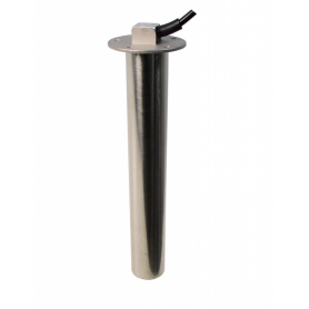
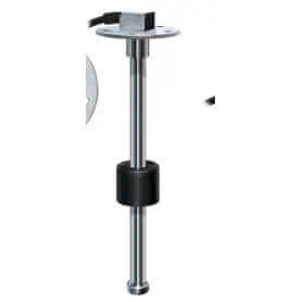
The VDO tubular sensor art. ES-224-011-0500 is a measuring device designed for continuous monitoring of the fuel level or other fluids inside tanks. It operates with a resistive signal between 0 and 180 Ohms, a standard widely used in VDO instruments, ensuring reliable readings and compatibility with numerous analogue indicators. Thanks to its length of 500 mm, the sensor is suitable for medium-depth tanks and stands out for its tubular structure, which ensures mechanical strength, stability over time and precision in level detection. It is designed for nautical applications.
The VDO tubular sensor art. ES-224-011-0650 is a component designed for continuous measurement of fuel or other fluid levels inside tanks. It operates with a resistive signal from 0 to 180 Ohms, an established standard that ensures full compatibility with VDO instruments and indicators, guaranteeing stable and reliable readings over time. Length 650 mm.
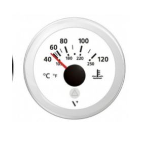
IP67 waterproof gauge designed for accurate water temperature monitoring, with a measuring range from 40 to 120 °C. Engineered for reliability and durability, it is ideal for marine, automotive, and industrial applications.
Equipped with a red illuminated warning light and integrated LED, it ensures clear and immediate readability even in low-light conditions.
Supplied complete with a round bezel for a clean, professional installation and connection cable for quick and easy setup.
Key Features:
Temperature range: 40–120 °C
Power supply: 12V / 24V
Protection rating: IP67 (dust-tight and water-resistant)
Integrated red LED illumination
Round bezel included
Connection cable included.
Compact, lightweight and durable, these 8x42 binoculars are ideal for navigation and observation at sea. They feature a built-in compass with rangefinder, allowing you to easily estimate the distance and size of observed objects.
Thanks to its BAK-7 roof prisms and fully multi-coated lenses, it delivers bright, clear images even in difficult lighting conditions. The focus ring on the eyepiece ensures quick and precise adjustments, while the waterproof construction makes it suitable for all weather conditions.
Magnification: 8x
Objective lens diameter: 42 mm
Dimensions: 143 x 60 mm
The AISI 316 STAINLESS STEEL level transmitter detects the level of fuel and water in recreational craft tanks; it has a 5-hole flange and comes complete with a rubber gasket.
The 240-33 OHM YAZAKI indicator is suitable for all instruments with a frequency of 240-33 OHM: YAZAKI - AQUA METER - TELEFLEX - GFN.
Length 225 mm.
*Compliant with the safety requirements established by Directive 94/25/EC. Reference standard ISO 8864*
Flush-mounted fuel gauge, IP67 protection rating, equipped with night lighting for perfect readability even in poor visibility conditions.
Made with a technopolymer casing, anti-fog glass, and AISI 316L stainless steel frame, it guarantees high corrosion resistance, ideal for nautical applications and harsh environments.
White dial.
Technical characteristics
Scale: E – 1/2 – F
Power supply: 9 – 32 V
Recessed diameter: 52 mm
Protection rating: IP67
Lighting: integrated for night use
Pick a color, then click OK